Screenshots
App Screenshots
Clean, intuitive interface designed for Indian drivers
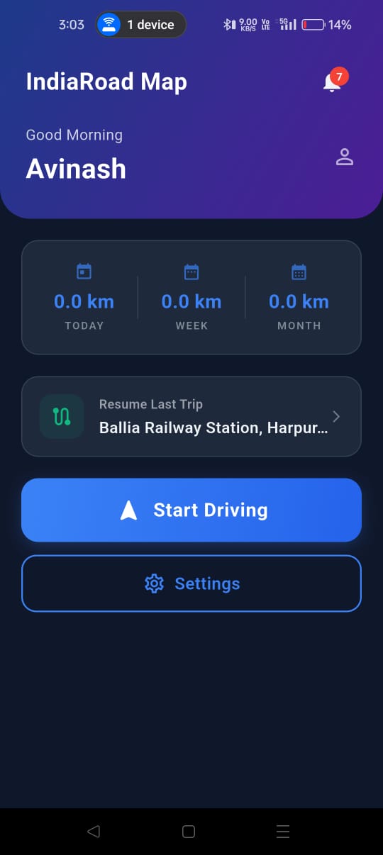
Dashboard
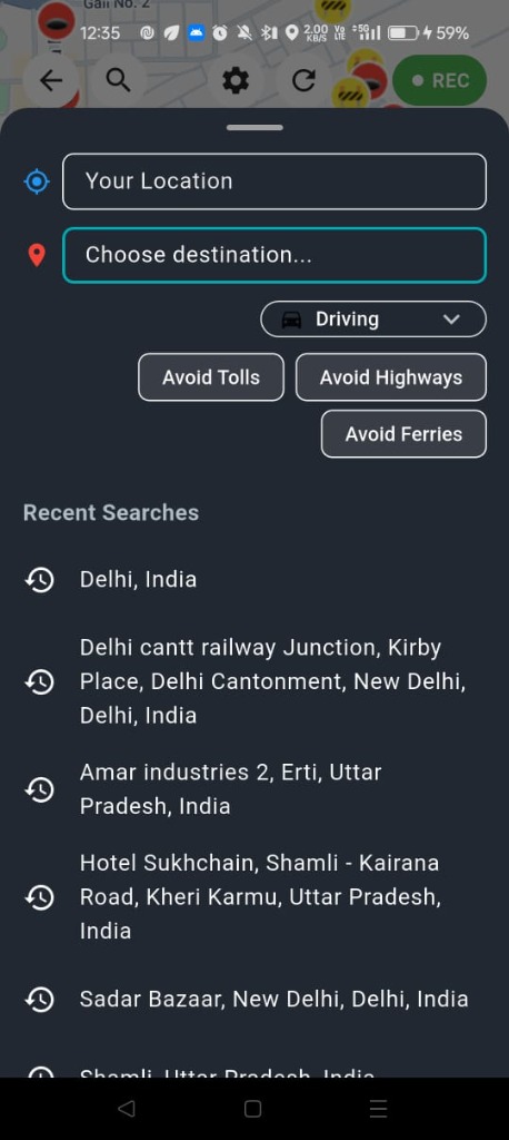
Smart Search
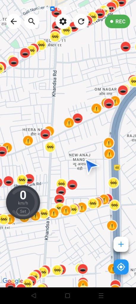
Live Navigation
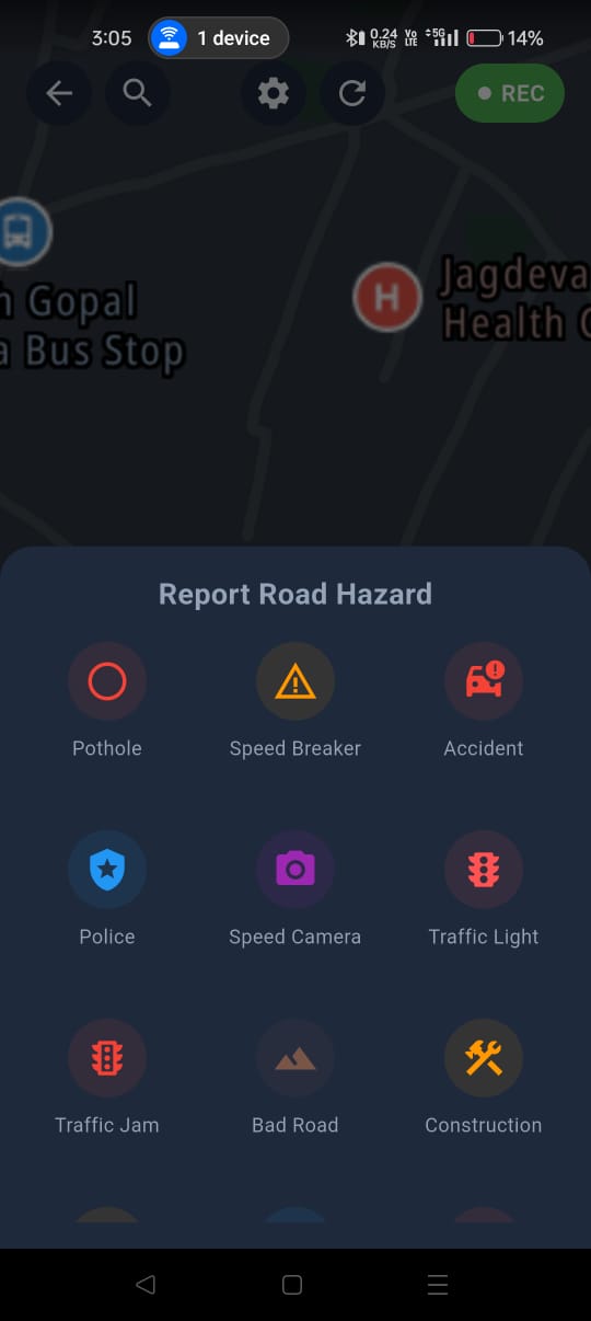
Hazard Reporting
INTELLIGENT HAZARD DETECTION & ROUTING SYSTEM
Indian roads are unique — from smooth highways to pothole-filled streets. Regular navigation apps don't account for road quality. We do.
Built by Avinash, a solo developer passionate about making every journey safer. This isn't just an app — it's a mission to protect vehicles and passengers across India.
Tracking hazards and routing logic sequentially
Advanced AI automatically scans and logs potholes, speed breakers, and damaged roads dynamically as you drive. Warnings are dispatched at critical intervals (200m & 50m).
Color-coded velocity visualization precisely maps congestion zones. Our routing engine actively compares three distinct alternate pathways simultaneously.
Real-time comparative analysis against logged speed limits. Receive instant visual and auditory alerts when threshold velocities are surpassed.
A decentralized report processing system. Your hazard logs instantly update the main navigation matrix, actively protecting subsequent convoy vehicles.
Personalize your experience for maximum safety
Fine-tune detection sensitivity (1–10 scale) for potholes, speed breakers, and bad roads. Perfect for different vehicle types.
Select Car or Bike mode for optimized detection. Each vehicle experiences road conditions differently.
One-tap calibration ensures accurate detection. Auto-calibrates on startup for hassle-free experience.
Navigate while using other apps. Floating window keeps directions visible when multitasking.
Music volume automatically lowers during voice instructions, then returns to normal. Never miss a turn.
Screen dims automatically on long straight roads to save battery. Brightens before turns and hazards.
Simple to use, powerful under the hood
Install the app and create your free account. One-time setup, stay logged in forever.
Search for any place in India. Choose your travel mode and route preferences.
Follow voice guidance while our sensors monitor road quality in real-time.
Receive timely alerts about potholes, speed breakers, and bad roads ahead.
Clean, intuitive interface designed for Indian drivers
Real stories from users saving time and avoiding potholes across India.
"Driving in Bangalore is a nightmare with unexpected potholes. This app saved my suspension twice this week! The alerts are spot on."
"The dashboard view is so clean, especially at night. It detected those massive speed breakers on the highway that are barely visible. A must-have."
"I love the community reporting. It feels like we're all helping each other. The offline mode is also surprisingly good for a free app."
Common questions about IndiaRoad Map
Yes, IndiaRoad Map is 100% free to download and use. There are no subscription fees or hidden charges.
Yes! We support offline navigation. However, real-time traffic updates and syncing new hazard reports require an active internet connection.
The app uses your phone's built-in sensors (accelerometer & gyroscope) to analyze road vibrations. Our AI algorithm distinguishes between normal bumps, speed breakers, and potholes.
Absolutely. Your location is used strictly for navigation and crowd-sourcing road quality. We do not sell your personal movement data.
Join thousands of drivers already using IndiaRoad Map
Download on Google Play — It's Free!